Radstationen: Unterschied zwischen den Versionen
| (42 dazwischenliegende Versionen desselben Benutzers werden nicht angezeigt) | |||
| Zeile 2: | Zeile 2: | ||
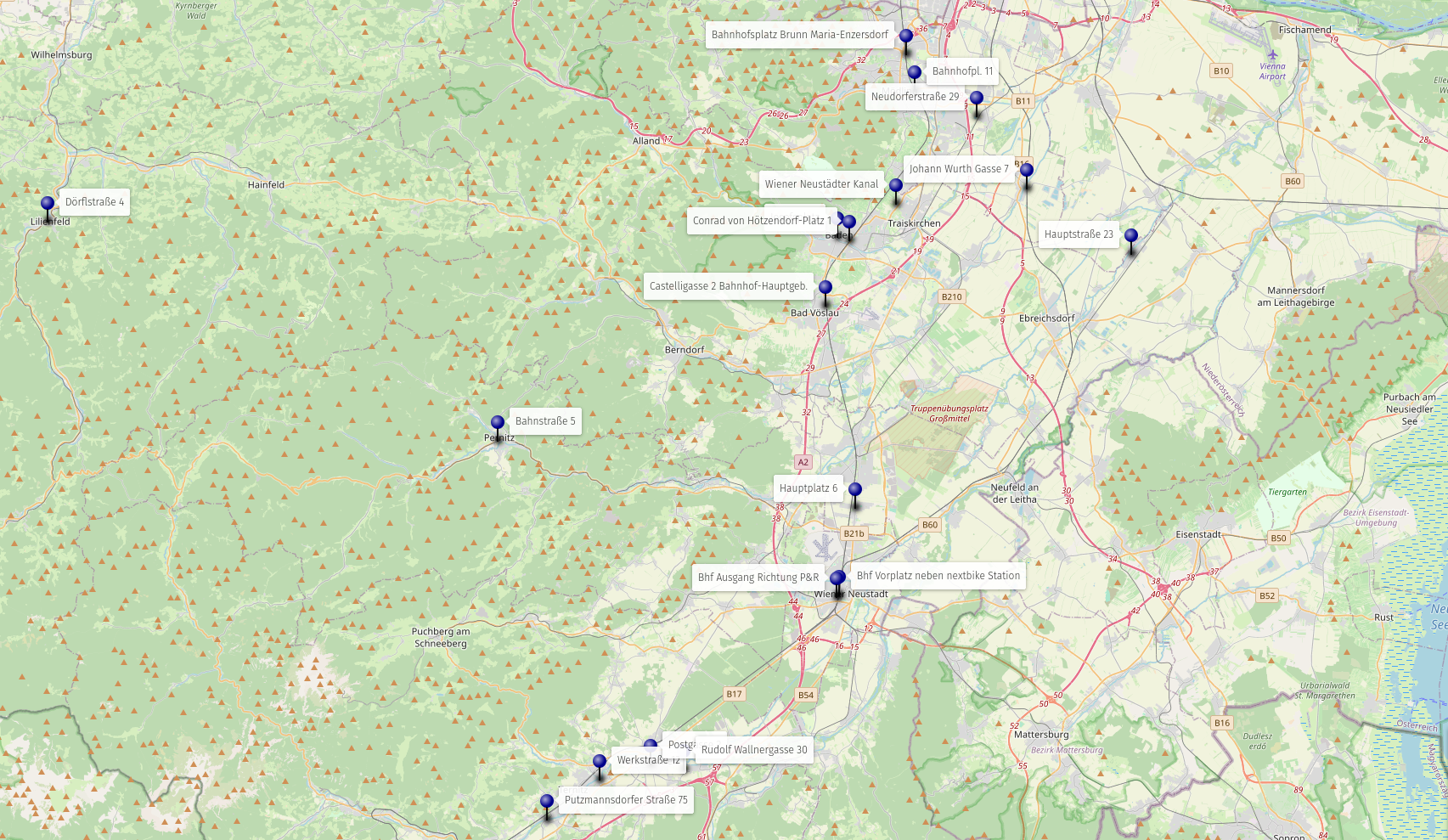
Quellen: | [[file:Radstationen.png|link=https://umap.openstreetmap.fr/de/map/radstationen-schwarzatalorg_1080974#11/47.9083/16.1787]] | ||
Quellen: | |||
https://radland.at/service-stationen/ | https://radland.at/service-stationen/ | ||
| Zeile 12: | Zeile 14: | ||
== | ==Bad Vöslau== | ||
=== | ===Castelligasse 2 Bahnhof-Hauptgeb.=== | ||
{{#widget:Iframe | |||
|url=https://www.google.com/maps/embed?pb=!4v1755994015783!6m8!1m7!1szP4Do1349iHPsKRThYwnLw!2m2!1d47.96922329461253!2d16.22314880162714!3f119.35!4f-5.480000000000004!5f3.325193203789971 | |||
|width=300 | |||
|height=300 | |||
|border=0 | |||
}} | |||
[https://www.google.com/maps/@47.9692233,16.2231488,3a,15y,119.35h,84.52t/data=!3m7!1e1!3m5!1szP4Do1349iHPsKRThYwnLw!2e0!6shttps:%2F%2Fstreetviewpixels-pa.googleapis.com%2Fv1%2Fthumbnail%3Fpanoid%3DzP4Do1349iHPsKRThYwnLw%26cb_client%3Dmaps_sv.share%26w%3D900%26h%3D600%26yaw%3D119.35263876337947%26pitch%3D5.476636738065864%26thumbfov%3D90!7i16384!8i8192?coh=205410&entry=ttu 360°-Foto] | |||
[[file:osm.png|24px|link= | [[file:osm.png|24px|link=]] https://www.openstreetmap.org/node/11623672106 | ||
''' | '''🧭''' 47.9691416,16.2233296 | ||
[[file:OrganicMaps.png|20px|link=|Organic Maps]] https://maps.app.goo.gl/ME7GUFtLzMQDWThv6 | |||
<br><br><br><br> | |||
==Baden== | |||
===Josefsplatz=== | |||
{{#widget:Iframe | |||
|url=https://www.google.com/maps/embed?pb=!4v1755994057173!6m8!1m7!1sLVivX8MPwNGLpxjoLNRLFQ!2m2!1d48.00651341044899!2d16.23264430800227!3f97.53!4f-5.689999999999998!5f3.325193203789971 | |||
|width=300 | |||
|height=300 | |||
|border=0 | |||
}} | |||
== | [https://www.google.com/maps/@48.0065134,16.2326443,3a,15y,97.53h,84.31t/data=!3m7!1e1!3m5!1sLVivX8MPwNGLpxjoLNRLFQ!2e0!6shttps:%2F%2Fstreetviewpixels-pa.googleapis.com%2Fv1%2Fthumbnail%3Fpanoid%3DLVivX8MPwNGLpxjoLNRLFQ%26cb_client%3Dmaps_sv.share%26w%3D900%26h%3D600%26yaw%3D97.52982006316587%26pitch%3D5.693154713473135%26thumbfov%3D90!7i16384!8i8192?coh=205410&entry=ttu 360°-Foto] | ||
= | [[file:osm.png|24px|link=]] https://www.openstreetmap.org/node/9368223336 | ||
''' | '''🧭''' 48.00650151915868, 16.232788266729674 | ||
[[file: | [[file:OrganicMaps.png|20px|link=|Organic Maps]] https://maps.app.goo.gl/qBKNVoRn2xz8fx1A9 | ||
<br><br><br><br> | |||
===Conrad von Hötzendorf-Platz 1=== | |||
{{#widget:Iframe | |||
|url=https://www.google.com/maps/embed?pb=!4v1755994079541!6m8!1m7!1sYOvXEZVydFgbJGrIFBlpcQ!2m2!1d48.00452853355672!2d16.24270280295194!3f123.1!4f-1.5!5f3.325193203789971 | |||
|width=300 | |||
|height=300 | |||
|border=0 | |||
}} | |||
[https://www.google.com/maps/@48.0045285,16.2427028,3a,15y,123.1h,88.5t/data=!3m7!1e1!3m5!1sYOvXEZVydFgbJGrIFBlpcQ!2e0!6shttps:%2F%2Fstreetviewpixels-pa.googleapis.com%2Fv1%2Fthumbnail%3Fpanoid%3DYOvXEZVydFgbJGrIFBlpcQ%26cb_client%3Dmaps_sv.share%26w%3D900%26h%3D600%26yaw%3D123.09746950132433%26pitch%3D1.498104547085461%26thumbfov%3D90!7i16384!8i8192?coh=205410&entry=ttu 360°-Foto] | |||
[[file:osm.png|24px|link=]] https://www.openstreetmap.org/node/1982602553 | |||
'''🧭''' 48.004572725330355, 16.242926096831244 | |||
= | [[file:OrganicMaps.png|20px|link=|Organic Maps]] https://maps.app.goo.gl/VTBg8ybvS5xQm6aQ6 | ||
<br><br><br><br> | |||
=== | ==Brunn am Gebirge== | ||
===Bahnhofsplatz Brunn Maria-Enzersdorf=== | |||
{{#widget:Iframe | |||
|url=https://www.google.com/maps/embed?pb=!4v1755994098979!6m8!1m7!1smzVtnZBByxvU7FsviSeuXA!2m2!1d48.10483680347439!2d16.28851021176051!3f295.52!4f-8.719999999999999!5f3.325193203789971 | |||
|width=300 | |||
|height=300 | |||
|border=0 | |||
}} | |||
[ | [https://www.google.com/maps/@48.1048368,16.2885102,3a,15y,295.52h,81.28t/data=!3m7!1e1!3m5!1smzVtnZBByxvU7FsviSeuXA!2e0!6shttps:%2F%2Fstreetviewpixels-pa.googleapis.com%2Fv1%2Fthumbnail%3Fpanoid%3DmzVtnZBByxvU7FsviSeuXA%26cb_client%3Dmaps_sv.share%26w%3D900%26h%3D600%26yaw%3D295.5239384585978%26pitch%3D8.718617745007904%26thumbfov%3D90!7i16384!8i8192?coh=205410&entry=ttu 360°-Foto] | ||
[[file:osm.png|24px|link=]] https://www.openstreetmap.org/node/7017826840 | |||
''' | '''🧭''' 48.104858741335704, 16.288419443989845 | ||
[[file:OrganicMaps.png|20px|link=|Organic Maps]] https://maps.app.goo.gl/p7yf4fQJmf7o2roy6 | |||
<br><br><br><br> | |||
==Laxenburg== | |||
== | ===Neudorferstraße 29=== | ||
{{#widget:Iframe | |||
|url=https://www.google.com/maps/embed?pb=!4v1755994124353!6m8!1m7!1sLRhl4SQd2KGQPOu2VtkZBQ!2m2!1d48.07181515341456!2d16.34555736149798!3f236.32!4f-15.439999999999998!5f3.325193203789971 | |||
|width=300 | |||
|height=300 | |||
|border=0 | |||
}} | |||
[https://www.google.com/maps/place/Neudorfer+Str.+29,+2631+Laxenburg/@48.0718152,16.3455574,3a,15y,236.32h,74.56t/data=!3m7!1e1!3m5!1sLRhl4SQd2KGQPOu2VtkZBQ!2e0!6shttps:%2F%2Fstreetviewpixels-pa.googleapis.com%2Fv1%2Fthumbnail%3Fpanoid%3DLRhl4SQd2KGQPOu2VtkZBQ%26cb_client%3Dmaps_sv.share%26w%3D900%26h%3D600%26yaw%3D236.31726598591615%26pitch%3D15.437292143775196%26thumbfov%3D90!7i16384!8i8192!4m15!1m8!3m7!1s0x476dae876487bb9d:0xa34c10e0d7e2ccdb!2sNeudorfer+Str.+29,+2631+Laxenburg!3b1!8m2!3d48.0716914!4d16.3456808!16s%2Fg%2F11kbm43x02!3m5!1s0x476dae876487bb9d:0xa34c10e0d7e2ccdb!8m2!3d48.0716914!4d16.3456808!16s%2Fg%2F11kbm43x02?coh=205410&entry=ttu 360°-Foto] | |||
= | [[file:osm.png|24px|link=]] https://www.openstreetmap.org/node/8457544338 | ||
''' | '''🧭''' 48.071791384840544, 16.34548979558414 | ||
[[file: | [[file:OrganicMaps.png|20px|link=|Organic Maps]] https://maps.app.goo.gl/cvygSKbpZuVy3vic8 | ||
<br><br><br><br> | |||
==Lilienfeld== | |||
===Dörflstraße 4=== | |||
{{#widget:Iframe | |||
|url=https://www.google.com/maps/embed?pb=!4v1755994149636!6m8!1m7!1sPz3ozS4lJv-hTRm8Mgim0g!2m2!1d48.0148324191159!2d15.59433668724565!3f333.36!4f-11.439999999999998!5f3.325193203789971 | |||
|width=300 | |||
|height=300 | |||
|border=0 | |||
}} | |||
[https://www.google.com/maps/@48.0148333,15.5943303,3a,15y,333.36h,78.56t/data=!3m7!1e1!3m5!1sPz3ozS4lJv-hTRm8Mgim0g!2e0!6shttps:%2F%2Fstreetviewpixels-pa.googleapis.com%2Fv1%2Fthumbnail%3Fpanoid%3DPz3ozS4lJv-hTRm8Mgim0g%26cb_client%3Dmaps_sv.share%26w%3D900%26h%3D600%26yaw%3D333.356230035277%26pitch%3D11.438737951522882%26thumbfov%3D90!7i16384!8i8192?coh=205410&entry=ttu 360°-Foto] | |||
[[file:osm.png|24px|link=]] https://www.openstreetmap.org/node/9592455874 | |||
'''🧭''' 48.014906747965505, 15.594291586415626 | |||
= | [[file:OrganicMaps.png|20px|link=|Organic Maps]] https://maps.app.goo.gl/N51xcU6iQaD1ajrz5 | ||
<br><br><br><br> | |||
==Mitterndorf an der Fischa== | |||
===Hauptstraße 23=== | |||
{{#widget:Iframe | |||
|url=https://www.google.com/maps/embed?pb=!4v1755994177838!6m8!1m7!1ssBnpvIHMfoFHeZCgwFHkEw!2m2!1d47.99724702255815!2d16.4706581417493!3f320.8!4f-10.010000000000005!5f2.235749511123945 | |||
|width=300 | |||
|height=300 | |||
|border=0 | |||
}} | |||
'' | [https://www.google.com/maps/place/47%C2%B059'50.3%22N+16%C2%B028'14.1%22E/@47.997247,16.4706581,3a,75y,319.52h,90t/data=!3m7!1e1!3m5!1ssBnpvIHMfoFHeZCgwFHkEw!2e0!6shttps:%2F%2Fstreetviewpixels-pa.googleapis.com%2Fv1%2Fthumbnail%3Fcb_client%3Dmaps_sv.tactile%26w%3D900%26h%3D600%26pitch%3D0%26panoid%3DsBnpvIHMfoFHeZCgwFHkEw%26yaw%3D319.52353!7i16384!8i8192!4m4!3m3!8m2!3d47.9973134!4d16.4705734?entry=ttu&g_ep=EgoyMDI1MDgxOS4wIKXMDSoASAFQAw%3D%3D 360°-Foto] | ||
[[file:osm.png|24px|link=]] https://www.openstreetmap.org/node/9900554681 | |||
'''🧭''' 47.997313364229946, 16.470573442185373 | |||
[[file:OrganicMaps.png|20px|link=|Organic Maps]] https://maps.app.goo.gl/DyYj6KejFQ7sLfbJA | |||
<br><br><br><br> | |||
== | ==Mödling== | ||
===Bahnhofpl. 11=== | |||
{{#widget:Iframe | |||
|url=https://www.google.com/maps/embed?pb=!4v1755994215701!6m8!1m7!1sB7fyqq-S1Tl6VnVpBBmenA!2m2!1d48.08524113716644!2d16.29528944008615!3f100.11!4f-3.8100000000000023!5f3.325193203789971 | |||
|width=300 | |||
|height=300 | |||
|border=0 | |||
}} | |||
= | |||
[https://www.google.com/maps/@48.0852411,16.2952894,3a,15y,100.11h,86.19t/data=!3m7!1e1!3m5!1sB7fyqq-S1Tl6VnVpBBmenA!2e0!6shttps:%2F%2Fstreetviewpixels-pa.googleapis.com%2Fv1%2Fthumbnail%3Fpanoid%3DB7fyqq-S1Tl6VnVpBBmenA%26cb_client%3Dmaps_sv.share%26w%3D900%26h%3D600%26yaw%3D100.11219098528456%26pitch%3D3.807437138516491%26thumbfov%3D90!7i16384!8i8192?coh=205410&entry=ttu 360°-Foto] | |||
[[file:osm.png|24px|link= | [[file:osm.png|24px|link=]] https://www.openstreetmap.org/node/3710225296 | ||
'''🧭''' 48.08532287419636, 16.29545319013206 | |||
[[file:OrganicMaps.png|20px|link=|Organic Maps]] https://maps.app.goo.gl/gCww3Cs8dfKQwPcB8 | |||
<br><br><br><br> | |||
==Münchendorf== | ==Münchendorf== | ||
===Johann Wurth Gasse 7=== | ===Johann Wurth Gasse 7=== | ||
{{#widget:Iframe | |||
|url=https://www.google.com/maps/embed?pb=!4v1755994219884!6m8!1m7!1smZHPntcmOn7ckBv3qnxshA!2m2!1d48.03249994437045!2d16.38565927646767!3f68.57!4f-11.299999999999997!5f1.5505061807131417 | |||
|width=300 | |||
|height=300 | |||
|border=0 | |||
}} | |||
[https://www.google.com/maps/@48.0324999,16.3856593,3a,48.5y,68.57h,78.7t/data=!3m7!1e1!3m5!1smZHPntcmOn7ckBv3qnxshA!2e0!6shttps:%2F%2Fstreetviewpixels-pa.googleapis.com%2Fv1%2Fthumbnail%3Fpanoid%3DmZHPntcmOn7ckBv3qnxshA%26cb_client%3Dmaps_sv.share%26w%3D900%26h%3D600%26yaw%3D68.57353478046068%26pitch%3D11.295558825398984%26thumbfov%3D90!7i16384!8i8192?coh=205410&entry=ttu 360°-Foto] | |||
[[file:osm.png|24px|link= | [[file:osm.png|24px|link=]] https://www.openstreetmap.org/node/6388598846 | ||
''' | '''🧭''' 48.0325459057901, 16.38572700223887 | ||
[[file:OrganicMaps.png|20px|link=|Organic Maps]] https://maps.app.goo.gl/fdviLFx6ryP4ZDBU7 | |||
<br><br><br><br> | |||
==Natschbach-Loipersbach== | |||
===Rudolf Wallnergasse 30=== | |||
{{#widget:Iframe | |||
|url=https://www.google.com/maps/embed?pb=!4v1755995319962!6m8!1m7!1s1TqCnJXXUtLEvFNaUBInqg!2m2!1d47.71780469887612!2d16.10900583107318!3f314.7!4f-27.6!5f0.7820865974627469 | |||
|width=300 | |||
|height=300 | |||
|border=0 | |||
}} | |||
== | [https://www.google.com/maps/@47.7178047,16.1090058,3a,75y,314.7h,62.4t/data=!3m7!1e1!3m5!1s1TqCnJXXUtLEvFNaUBInqg!2e0!6shttps:%2F%2Fstreetviewpixels-pa.googleapis.com%2Fv1%2Fthumbnail%3Fpanoid%3D1TqCnJXXUtLEvFNaUBInqg%26cb_client%3Dmaps_sv.share%26w%3D900%26h%3D600%26yaw%3D314.69906656576853%26pitch%3D27.60158067295034%26thumbfov%3D90!7i16384!8i8192?coh=205410&entry=ttu 360°-Foto] | ||
= | [[file:osm.png|24px|link=]] https://www.openstreetmap.org/node/7366673616 | ||
''' | '''🧭''' 47.71783443988949, 16.108943690654026 | ||
[[file: | [[file:OrganicMaps.png|20px|link=|Organic Maps]] https://maps.app.goo.gl/nNNDx1vUi2DWyR1N7 | ||
<br><br><br><br> | |||
==Neunkirchen== | |||
===Postgasse 2=== | |||
{{#widget:Iframe | |||
|url=https://www.google.com/maps/embed?pb=!4v1755994228026!6m8!1m7!1swnHjyPrz9zAPaS_K9L2mWA!2m2!1d47.72059062246179!2d16.08216440772254!3f57.93!4f-26.689999999999998!5f0.7820865974627469 | |||
|width=300 | |||
|height=300 | |||
|border=0 | |||
}} | |||
[https://www.google.com/maps/@47.7205906,16.0821644,3a,75y,57.93h,63.31t/data=!3m6!1e1!3m4!1swnHjyPrz9zAPaS_K9L2mWA!2e0!7i16384!8i8192?coh=205409&entry=ttu 360°-Foto] | |||
[[file:osm.png|24px|link=]] https://www.openstreetmap.org/node/7846451412 | |||
'''🧭''' 47.720633026952314, 16.082242862328773 | |||
= | [[file:OrganicMaps.png|20px|link=|Organic Maps]] https://maps.app.goo.gl/KbeQw6CkX8fbPDXZA | ||
<br><br><br><br> | |||
==Pernitz== | |||
===Bahnstraße 5=== | |||
{{#widget:Iframe | |||
|url=https://www.google.com/maps/embed?pb=!4v1756032975000!6m8!1m7!1sKHrfHZixP-GrnFUwxaX0sA!2m2!1d47.8962160263678!2d15.95835021176699!3f171.42460175459317!4f-5.503089681164624!5f3.325193203789971 | |||
|width=300 | |||
|height=300 | |||
|border=0 | |||
}} | |||
[https://www.google.com/maps/@47.896216,15.9583502,3a,15y,171.42h,84.5t/data=!3m7!1e1!3m5!1sKHrfHZixP-GrnFUwxaX0sA!2e0!6shttps:%2F%2Fstreetviewpixels-pa.googleapis.com%2Fv1%2Fthumbnail%3Fcb_client%3Dmaps_sv.tactile%26w%3D900%26h%3D600%26pitch%3D5.503089681164624%26panoid%3DKHrfHZixP-GrnFUwxaX0sA%26yaw%3D171.42460175459317!7i16384!8i8192?entry=ttu&g_ep=EgoyMDI1MDgxOS4wIKXMDSoASAFQAw%3D%3D 360°-Foto] | |||
[[file:osm.png|24px|link=]] https://www.openstreetmap.org/node/4614969772 | |||
'''🧭''' 47.89610962468225, 15.958278038692027 | |||
[[file:OrganicMaps.png|20px|link=|Organic Maps]] https://maps.app.goo.gl/Y55F6UxJJUidvmbQ9 | |||
<br><br><br><br> | |||
== | ==Pressbaum== | ||
=== | ===Hauptstraße 89=== | ||
? | |||
''' | '''360°-Fotos''': [ google.com] | ||
[[file:osm.png|24px|link= | [[file:osm.png|24px|link=]] | ||
''' | '''🧭''' | ||
[[file:OrganicMaps.png|20px|link=|Organic Maps]] | |||
<br><br><br><br> | |||
==Putzmannsdorf== | |||
===Putzmannsdorfer Straße 75=== | |||
{{#widget:Iframe | |||
|url=https://www.google.com/maps/embed?pb=!4v1755994358618!6m8!1m7!1sfjh32B9xN91NN6yr33Jz1Q!2m2!1d47.69046738986417!2d15.9982902516297!3f297.35!4f-12.340000000000003!5f1.1924812503605782 | |||
|width=300 | |||
|height=300 | |||
|border=0 | |||
}} | |||
[https://www.google.com/maps/@47.6904674,15.9982903,3a,60y,297.35h,77.66t/data=!3m7!1e1!3m5!1sfjh32B9xN91NN6yr33Jz1Q!2e0!6shttps:%2F%2Fstreetviewpixels-pa.googleapis.com%2Fv1%2Fthumbnail%3Fpanoid%3Dfjh32B9xN91NN6yr33Jz1Q%26cb_client%3Dmaps_sv.share%26w%3D900%26h%3D600%26yaw%3D297.35252469516325%26pitch%3D12.33796474118408%26thumbfov%3D90!7i16384!8i8192?coh=205410&entry=ttu 360°-Foto] | |||
[[file:osm.png|24px|link= | [[file:osm.png|24px|link=]] https://www.openstreetmap.org/node/7729021842 | ||
'''🧭''' 47.69055729656957, 15.99817457745267 | |||
[[file:OrganicMaps.png|20px|link=|Organic Maps]] https://maps.app.goo.gl/UEjMjvgX8yQTxBvW8 | |||
<br><br><br><br> | |||
==Schwechat== | ==Schwechat== | ||
===Bhf Vorplatz neben nextbike Station=== | ===Bhf Vorplatz neben nextbike Station=== | ||
{{#widget:Iframe | |||
|url=https://www.google.com/maps/embed?pb=!4v1755994364057!6m8!1m7!1shB2WbFuUxbiewJDI92FRbg!2m2!1d48.1427669675892!2d16.48185193065434!3f59.41!4f-2.6700000000000017!5f3.325193203789971 | |||
|width=300 | |||
|height=300 | |||
|border=0 | |||
}} | |||
[https://www.google.com/maps/@48.142767,16.4818519,3a,15y,59.41h,87.33t/data=!3m7!1e1!3m5!1shB2WbFuUxbiewJDI92FRbg!2e0!6shttps:%2F%2Fstreetviewpixels-pa.googleapis.com%2Fv1%2Fthumbnail%3Fpanoid%3DhB2WbFuUxbiewJDI92FRbg%26cb_client%3Dmaps_sv.share%26w%3D900%26h%3D600%26yaw%3D59.41439715702933%26pitch%3D2.6658397432345424%26thumbfov%3D90!7i16384!8i8192?coh=205410&entry=ttu 360°-Foto] | |||
[[file:osm.png|24px|link=https:// | [[file:osm.png|24px|link=]] https://www.openstreetmap.org/node/4254886318 | ||
''' | '''🧭''' 48.14296589553021, 16.482168010622637 | ||
[[file:OrganicMaps.png|20px|link=|Organic Maps]] https://maps.app.goo.gl/qL3FvFBTx7Cxm7eAA | |||
<br><br><br><br> | |||
==Ternitz== | |||
===Werkstraße 12=== | |||
{{#widget:Iframe | |||
|url=https://www.google.com/maps/embed?pb=!4v1755994367297!6m8!1m7!1sgncyXDtc5c1rCmd1xoQ-mg!2m2!1d47.71221629347155!2d16.04064780344056!3f75.81!4f-5.950000000000003!5f2.4639761743867545 | |||
|width=300 | |||
|height=300 | |||
|border=0 | |||
}} | |||
== | [https://www.google.com/maps/@47.7122163,16.0406478,3a,26.9y,75.81h,84.05t/data=!3m7!1e1!3m5!1sgncyXDtc5c1rCmd1xoQ-mg!2e0!6shttps:%2F%2Fstreetviewpixels-pa.googleapis.com%2Fv1%2Fthumbnail%3Fpanoid%3DgncyXDtc5c1rCmd1xoQ-mg%26cb_client%3Dsearch.revgeo_and_fetch.gps%26w%3D96%26h%3D64%26yaw%3D88.91267%26pitch%3D0%26thumbfov%3D100!7i16384!8i8192?coh=205409&entry=ttu 360°-Foto] | ||
= | [[file:osm.png|24px|link=]] https://www.openstreetmap.orgnode/9827809738 | ||
''' | '''🧭''' 47.712292848895174, 16.04092281226928 | ||
[[file: | [[file:OrganicMaps.png|20px|link=|Organic Maps]] https://maps.app.goo.gl/TxRsQCCzSiw5TotX9 | ||
<br><br><br><br> | |||
==Theresienfeld== | |||
===Hauptplatz 6=== | |||
{{#widget:Iframe | |||
|url=https://www.google.com/maps/embed?pb=!4v1755994370870!6m8!1m7!1sLNkM7MSY7u7FbI4sZBxO1A!2m2!1d47.85973221625084!2d16.24773981345042!3f280.93!4f-8.319999999999993!5f3.29628841717088 | |||
|width=300 | |||
|height=300 | |||
|border=0 | |||
}} | |||
[https://www.google.com/maps/place/Hauptpl.+6,+2604+Theresienfeld/@47.8597322,16.2477398,3a,15.3y,280.93h,81.68t/data=!3m7!1e1!3m5!1sLNkM7MSY7u7FbI4sZBxO1A!2e0!6shttps:%2F%2Fstreetviewpixels-pa.googleapis.com%2Fv1%2Fthumbnail%3Fpanoid%3DLNkM7MSY7u7FbI4sZBxO1A%26cb_client%3Dmaps_sv.share%26w%3D900%26h%3D600%26yaw%3D280.92962690081083%26pitch%3D8.320001841509082%26thumbfov%3D90!7i16384!8i8192!4m15!1m8!3m7!1s0x476dca3d1bc2fee9:0x6b9d63aa8d5535ad!2sHauptpl.+6,+2604+Theresienfeld!3b1!8m2!3d47.8598939!4d16.2473856!16s%2Fg%2F11dzq2nmll!3m5!1s0x476dca3d1bc2fee9:0x6b9d63aa8d5535ad!8m2!3d47.8598939!4d16.2473856!16s%2Fg%2F11dzq2nmll?coh=205410&entry=ttu 360°-Foto] | |||
[[file:osm.png|24px|link=]] https://www.openstreetmap.org/node/1794420644 | |||
'''🧭''' 47.859725947718104, 16.24762137839611 | |||
= | [[file:OrganicMaps.png|20px|link=|Organic Maps]] https://maps.app.goo.gl/KUeGxh3awWfhP1X78 | ||
<br><br><br><br> | |||
==Traiskirchen== | |||
===Wiener Neustädter Kanal=== | |||
{{#widget:Iframe | |||
|url=https://www.google.com/maps/embed?pb=!4v1755994376569!6m8!1m7!1skXBLOStSCvK45H7HhUhFKQ!2m2!1d48.02420312743757!2d16.28081825732566!3f274.23!4f-6.790000000000006!5f0.7664674003678946 | |||
|width=300 | |||
|height=300 | |||
|border=0 | |||
}} | |||
[https://www.google.com/maps/@48.024234,16.2807725,3a,75.6y,274.23h,83.21t/data=!3m7!1e1!3m5!1skeObu5si6lJhXgH4v5oh1g!2e0!6shttps:%2F%2Fstreetviewpixels-pa.googleapis.com%2Fv1%2Fthumbnail%3Fpanoid%3DkeObu5si6lJhXgH4v5oh1g%26cb_client%3Dmaps_sv.share%26w%3D900%26h%3D600%26yaw%3D274.2303816775553%26pitch%3D6.793983292507903%26thumbfov%3D90!7i16384!8i8192?coh=205410&entry=ttu 360°-Foto] | |||
[[file:osm.png|24px|link=]] https://www.openstreetmap.org/node/9971573061 | |||
'''🧭''' 48.02425454194671, 16.280449314742974 | |||
[[file:OrganicMaps.png|20px|link=|Organic Maps]] https://maps.app.goo.gl/PoeaD7HUM1DthUuu8 | |||
<br><br><br><br> | |||
== | ==Wr. Neustadt== | ||
=== | ===Bhf Ausgang Richtung P&R=== | ||
{{#widget:Iframe | |||
|url=https://www.google.com/maps/embed?pb=!4v1755994485494!6m8!1m7!1sJj5hHyCfupnh83ptKlL2Tw!2m2!1d47.8120706669159!2d16.2333215758316!3f215.41883662149118!4f1.7546302981258748!5f0.9488975892535869 | |||
|width=300 | |||
|height=300 | |||
|border=0 | |||
}} | |||
[https://www.google.com/maps/place/%C3%96AMTC+Fahrrad-Station+Wiener+Neustadt/@47.8115291,16.231742,18z/data=!4m10!1m2!2m1!1sbhf+wr+neustdt+radstation!3m6!1s0x476dcb665f6da84f:0x50f11a1636aac806!8m2!3d47.8116929!4d16.2326105!15sCh5iYWhuaG9mIHdyIG5ldXN0YWR0IHJhZHN0YXRpb26SARNiaWN5Y2xlX3JlcGFpcl9zaG9w4AEA!16s%2Fg%2F11k8f1m913?entry=ttu 360°-Foto] | |||
[[file:osm.png|24px|link=https:// | [[file:osm.png|24px|link=]] https://www.openstreetmap.org/way/125205975#map=19/47.81141/16.23248 | ||
''' | '''🧭''' 47.8116964026558, 16.2326090032824371 | ||
[[file:OrganicMaps.png|20px|link=|Organic Maps]] https://maps.app.goo.gl/czpZu4xUJ2CW1Gme72 | |||
<br><br><br><br> | |||
===Bhf Vorplatz neben nextbike Station=== | |||
{{#widget:Iframe | |||
|url=https://www.google.com/maps/embed?pb=!4v1755994620262!6m8!1m7!1sekU7mxAcsSSp-kWtJw8paA!2m2!1d47.81204035786162!2d16.23501776467146!3f281.38!4f-0.29000000000000625!5f3.325193203789971 | |||
|width=300 | |||
|height=300 | |||
|border=0 | |||
}} | |||
[https://www.google.com/maps/@47.8120245,16.2350556,3a,15y,281.38h,89.71t/data=!3m7!1e1!3m5!1s9kp48NaueunYuL3PQkh5fg!2e0!6shttps:%2F%2Fstreetviewpixels-pa.googleapis.com%2Fv1%2Fthumbnail%3Fpanoid%3D9kp48NaueunYuL3PQkh5fg%26cb_client%3Dmaps_sv.share%26w%3D900%26h%3D600%26yaw%3D281.37828117519337%26pitch%3D0.29184491102502363%26thumbfov%3D90!7i16384!8i8192?coh=205410&entry=ttu 360°-Foto] | |||
[[file:osm.png|24px|link=]] https://www.openstreetmap.org/node/1552554379 | |||
[[file:osm.png|24px|link=https:// | |||
''' | '''🧭''' 47.81210189866528, 16.234490149591778 | ||
[[file:OrganicMaps.png|20px|link=|Organic Maps]] https://maps.app.goo.gl/211dENc5Ld69iKK66 | |||
<br><br><br><br> | |||
Aktuelle Version vom 24. August 2025, 11:57 Uhr
Hauptseite > Öffentlicher Verkehr > Fahrrad
Quellen:
https://radland.at/service-stationen/
openstreetmap.org
maps.google.com
Bad Vöslau
Castelligasse 2 Bahnhof-Hauptgeb.
![]() https://www.openstreetmap.org/node/11623672106
https://www.openstreetmap.org/node/11623672106
🧭 47.9691416,16.2233296
![]() https://maps.app.goo.gl/ME7GUFtLzMQDWThv6
https://maps.app.goo.gl/ME7GUFtLzMQDWThv6
Baden
Josefsplatz
![]() https://www.openstreetmap.org/node/9368223336
https://www.openstreetmap.org/node/9368223336
🧭 48.00650151915868, 16.232788266729674
![]() https://maps.app.goo.gl/qBKNVoRn2xz8fx1A9
https://maps.app.goo.gl/qBKNVoRn2xz8fx1A9
Conrad von Hötzendorf-Platz 1
![]() https://www.openstreetmap.org/node/1982602553
https://www.openstreetmap.org/node/1982602553
🧭 48.004572725330355, 16.242926096831244
![]() https://maps.app.goo.gl/VTBg8ybvS5xQm6aQ6
https://maps.app.goo.gl/VTBg8ybvS5xQm6aQ6
Brunn am Gebirge
Bahnhofsplatz Brunn Maria-Enzersdorf
![]() https://www.openstreetmap.org/node/7017826840
https://www.openstreetmap.org/node/7017826840
🧭 48.104858741335704, 16.288419443989845
![]() https://maps.app.goo.gl/p7yf4fQJmf7o2roy6
https://maps.app.goo.gl/p7yf4fQJmf7o2roy6
Laxenburg
Neudorferstraße 29
![]() https://www.openstreetmap.org/node/8457544338
https://www.openstreetmap.org/node/8457544338
🧭 48.071791384840544, 16.34548979558414
![]() https://maps.app.goo.gl/cvygSKbpZuVy3vic8
https://maps.app.goo.gl/cvygSKbpZuVy3vic8
Lilienfeld
Dörflstraße 4
![]() https://www.openstreetmap.org/node/9592455874
https://www.openstreetmap.org/node/9592455874
🧭 48.014906747965505, 15.594291586415626
![]() https://maps.app.goo.gl/N51xcU6iQaD1ajrz5
https://maps.app.goo.gl/N51xcU6iQaD1ajrz5
Mitterndorf an der Fischa
Hauptstraße 23
![]() https://www.openstreetmap.org/node/9900554681
https://www.openstreetmap.org/node/9900554681
🧭 47.997313364229946, 16.470573442185373
![]() https://maps.app.goo.gl/DyYj6KejFQ7sLfbJA
https://maps.app.goo.gl/DyYj6KejFQ7sLfbJA
Mödling
Bahnhofpl. 11
![]() https://www.openstreetmap.org/node/3710225296
https://www.openstreetmap.org/node/3710225296
🧭 48.08532287419636, 16.29545319013206
![]() https://maps.app.goo.gl/gCww3Cs8dfKQwPcB8
https://maps.app.goo.gl/gCww3Cs8dfKQwPcB8
Münchendorf
Johann Wurth Gasse 7
![]() https://www.openstreetmap.org/node/6388598846
https://www.openstreetmap.org/node/6388598846
🧭 48.0325459057901, 16.38572700223887
![]() https://maps.app.goo.gl/fdviLFx6ryP4ZDBU7
https://maps.app.goo.gl/fdviLFx6ryP4ZDBU7
Natschbach-Loipersbach
Rudolf Wallnergasse 30
![]() https://www.openstreetmap.org/node/7366673616
https://www.openstreetmap.org/node/7366673616
🧭 47.71783443988949, 16.108943690654026
![]() https://maps.app.goo.gl/nNNDx1vUi2DWyR1N7
https://maps.app.goo.gl/nNNDx1vUi2DWyR1N7
Neunkirchen
Postgasse 2
![]() https://www.openstreetmap.org/node/7846451412
https://www.openstreetmap.org/node/7846451412
🧭 47.720633026952314, 16.082242862328773
![]() https://maps.app.goo.gl/KbeQw6CkX8fbPDXZA
https://maps.app.goo.gl/KbeQw6CkX8fbPDXZA
Pernitz
Bahnstraße 5
![]() https://www.openstreetmap.org/node/4614969772
https://www.openstreetmap.org/node/4614969772
🧭 47.89610962468225, 15.958278038692027
![]() https://maps.app.goo.gl/Y55F6UxJJUidvmbQ9
https://maps.app.goo.gl/Y55F6UxJJUidvmbQ9
Pressbaum
Hauptstraße 89
?
360°-Fotos: [ google.com]
![]()
🧭
![]()
Putzmannsdorf
Putzmannsdorfer Straße 75
![]() https://www.openstreetmap.org/node/7729021842
https://www.openstreetmap.org/node/7729021842
🧭 47.69055729656957, 15.99817457745267
![]() https://maps.app.goo.gl/UEjMjvgX8yQTxBvW8
https://maps.app.goo.gl/UEjMjvgX8yQTxBvW8
Schwechat
Bhf Vorplatz neben nextbike Station
![]() https://www.openstreetmap.org/node/4254886318
https://www.openstreetmap.org/node/4254886318
🧭 48.14296589553021, 16.482168010622637
![]() https://maps.app.goo.gl/qL3FvFBTx7Cxm7eAA
https://maps.app.goo.gl/qL3FvFBTx7Cxm7eAA
Ternitz
Werkstraße 12
![]() https://www.openstreetmap.orgnode/9827809738
https://www.openstreetmap.orgnode/9827809738
🧭 47.712292848895174, 16.04092281226928
![]() https://maps.app.goo.gl/TxRsQCCzSiw5TotX9
https://maps.app.goo.gl/TxRsQCCzSiw5TotX9
Theresienfeld
Hauptplatz 6
![]() https://www.openstreetmap.org/node/1794420644
https://www.openstreetmap.org/node/1794420644
🧭 47.859725947718104, 16.24762137839611
![]() https://maps.app.goo.gl/KUeGxh3awWfhP1X78
https://maps.app.goo.gl/KUeGxh3awWfhP1X78
Traiskirchen
Wiener Neustädter Kanal
![]() https://www.openstreetmap.org/node/9971573061
https://www.openstreetmap.org/node/9971573061
🧭 48.02425454194671, 16.280449314742974
![]() https://maps.app.goo.gl/PoeaD7HUM1DthUuu8
https://maps.app.goo.gl/PoeaD7HUM1DthUuu8
Wr. Neustadt
Bhf Ausgang Richtung P&R
![]() https://www.openstreetmap.org/way/125205975#map=19/47.81141/16.23248
https://www.openstreetmap.org/way/125205975#map=19/47.81141/16.23248
🧭 47.8116964026558, 16.2326090032824371
![]() https://maps.app.goo.gl/czpZu4xUJ2CW1Gme72
https://maps.app.goo.gl/czpZu4xUJ2CW1Gme72
Bhf Vorplatz neben nextbike Station
![]() https://www.openstreetmap.org/node/1552554379
https://www.openstreetmap.org/node/1552554379
🧭 47.81210189866528, 16.234490149591778